Sharing local approaches across Europe : diagnosis of heat vulnerability
On October 28th, partners gathered online for a thematic session dedicated to exploring different ways to understand territorial vulnerability — by combining quantitative data, physical indicators, and residents’ lived experiences.
Lille European Metropolis’ representative Ophélie Tainguy introduced the physical diagnosis for the Time2Adapt project, done to identify the areas most vulnerable to the risks of extreme heat.
The main approach to map this vulnerability was the 3-30-300 approach (Cecil Konijnendijk, 2021):
- 3 trees visible from each home or workplace for wellbeing,
- 30% tree canopy per neighbourhood for cooling and air quality,
- 300 metres maximum distance to a green space for accessibility and social life
This technical approach was complemented by the sensitive diagnosis, presented by Jeanne Zanardo from Ecologie Urbaine et Citoyenne (EUC). Through 3 months of participatory work during summer time — including mobile stands, sensitive walks, and online surveys across seven neighbourhoods in Lille and Loos — EUC collected residents’ perceptions of heat and comfort, focusing on groups most vulnerable due to age or living conditions. The result: a “sensitive map” reflecting how inhabitants actually experience temperature variations in their daily environment.
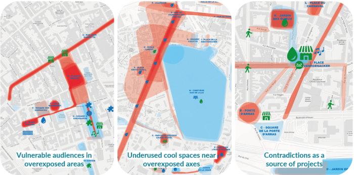
Result of participative heat map, by Ecologie Urbaine et Citoyenne
From Spain, Minerva Campos Sánchez and Elena Domena Gómez of Area Metropolitanea de Barcelona and Institut Metròpoli presented the Climate Vulnerability Index.
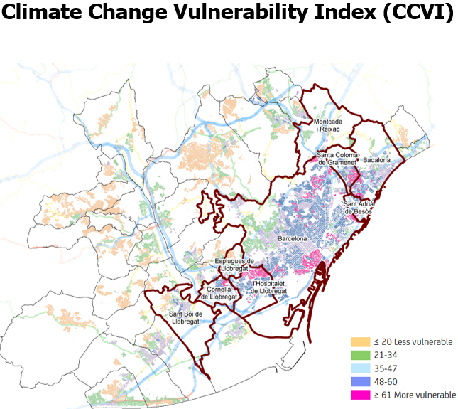
This index makes it possible to identify the areas most exposed to climate change’s effects at the neighbourhood level, by cross-referencing social, environmental and urban data.
It is designed to support cities and decision makers in prioritising adaptation actions — such as identifying optimal locations for climate shelters — and communicating clearly their choices to the public with a scientific basis.
A question remains now about how it could evolve and further integrate participatory inputs.
Throughout the session, participants also exchanged on existing mapping tools and shared reflections on how to better bridge data-driven insights and human-centred approaches.
This thematic meeting is one of many steps in Time2Adapt’s shared learning journey. By bringing together cities’ diverse expertise — from technical mapping to participatory engagement — the partnership continues to strengthen its collective understanding of how to make public spaces cooler, fairer, and more resilient.
Stay tuned for the next thematic session as Time2Adapt partners continue to learn, exchange, and adapt — one step, one season, one collaboration at a time.
Thanks to all participants, the moderator of the session Marcelline Bonneau, Lisa Fontaine and speakers Ophélie Tainguy (MEL), Jeanne Zanardo (EUC), Minerva Campos Sánchez (AMB) and Elena Domena Gómez (Institut Metropoli).
To go further:
- On the 3/30/300 method: https://nbsi.eu/the-3-30-300-rule/
- On the CCVI: https://recam.amb.cat/items/3fbb0f11-aa74-4e91-b4bd-fb3c8036ea3e